
 Wednesday, March 15, we made
the short trip from NW Phoenix to Quartzite, AZ, a little dusty town almost on the
California border on I-10. In January
and February there were nine gem and mineral shows here and fifteen flea markets. This snowbirder haven saw
800,000 RVers last winter! Yikes! Don’t come here in the summer, though. In the middle of summer, Quartzsite was one
of the hottest places in the United States and had recorded temperatures as
high as 122 °F on 28 July, 1995. By the time we arrived in the
middle of March there wasn’t a lot going on, but, you know us, we ferreted out
the most interesting spots in this desert town. The guy parked next to us went out into the
desert every day looking for gold and usually came back with a few flakes.
Wednesday, March 15, we made
the short trip from NW Phoenix to Quartzite, AZ, a little dusty town almost on the
California border on I-10. In January
and February there were nine gem and mineral shows here and fifteen flea markets. This snowbirder haven saw
800,000 RVers last winter! Yikes! Don’t come here in the summer, though. In the middle of summer, Quartzsite was one
of the hottest places in the United States and had recorded temperatures as
high as 122 °F on 28 July, 1995. By the time we arrived in the
middle of March there wasn’t a lot going on, but, you know us, we ferreted out
the most interesting spots in this desert town. The guy parked next to us went out into the
desert every day looking for gold and usually came back with a few flakes. Jerry was walking through
“Celia’s Rainbow Garden”, a memorial garden started by Celia’s mom in memory of
Celia who died at 9 years of age. You
can see that the caretakers aren’t big on watering and lawns, but it was
interesting to the various desert plants.
Jerry was walking through
“Celia’s Rainbow Garden”, a memorial garden started by Celia’s mom in memory of
Celia who died at 9 years of age. You
can see that the caretakers aren’t big on watering and lawns, but it was
interesting to the various desert plants.  Quartzite Cemetery was the burial place of Hi Jolly (Hadji Ali), an Ottoman citizen of Greek-Syrian parentage. Ali was one of several men hired by the United States
Army to introduce 33 camels as beasts
of burden to transport cargo across the "Great American Desert. After successfully traveling round trip from Texas to California, the experiment failed, partly due to the problem
that the Army's burros, horses, and mules feared the large animals, often panicking. The tensions of the American
Civil War led to Congress not approving more
funds for the Corps. In 1864, the camels
were finally auctioned off. In his final
years, Ali moved to Quartzsite, Arizona, where he
mined and occasionally scouted for the US government. He died in 1902 and was
buried in the Quartzsite Cemetery.Quartzite was also famous for
its flea markets and “commercial” yard sales.
We wandered the few remaining stands, but couldn’t find anything
appealing. The whole dusty, cramped
place kind of gave us the creeps as we imagined hundreds of thousands of
snowbirders pawing through the treasures.
I don’t think we will be back!
Quartzite Cemetery was the burial place of Hi Jolly (Hadji Ali), an Ottoman citizen of Greek-Syrian parentage. Ali was one of several men hired by the United States
Army to introduce 33 camels as beasts
of burden to transport cargo across the "Great American Desert. After successfully traveling round trip from Texas to California, the experiment failed, partly due to the problem
that the Army's burros, horses, and mules feared the large animals, often panicking. The tensions of the American
Civil War led to Congress not approving more
funds for the Corps. In 1864, the camels
were finally auctioned off. In his final
years, Ali moved to Quartzsite, Arizona, where he
mined and occasionally scouted for the US government. He died in 1902 and was
buried in the Quartzsite Cemetery.Quartzite was also famous for
its flea markets and “commercial” yard sales.
We wandered the few remaining stands, but couldn’t find anything
appealing. The whole dusty, cramped
place kind of gave us the creeps as we imagined hundreds of thousands of
snowbirders pawing through the treasures.
I don’t think we will be back! The only other item of
interest was a small museum displaying historic items from Quartzite's early days. The town of Quartzsite was located on the site of old Fort Tyson, a privately owned fort built in 1856 by Charles Tyson for protection against Indians. Because of the water which existed at this place, Tyson's Wells soon became a stage station on the road from Ehrenburg to Prescott. In 1875 Martha Summerhayes described this place as being the most melancholy and uninviting that she had ever seen, saying that it "reeks of everything unclean, morally and physically..."
The only other item of
interest was a small museum displaying historic items from Quartzite's early days. The town of Quartzsite was located on the site of old Fort Tyson, a privately owned fort built in 1856 by Charles Tyson for protection against Indians. Because of the water which existed at this place, Tyson's Wells soon became a stage station on the road from Ehrenburg to Prescott. In 1875 Martha Summerhayes described this place as being the most melancholy and uninviting that she had ever seen, saying that it "reeks of everything unclean, morally and physically..." We left Quartzite on March 18
to make our way to the central California coast. We had two stops along the way, since we
don’t like to travel more than 300 miles a day.
The first stop was in Barstow, at the Shady Lane RV Camp. Not one of my better selections! The sites were too small, the “camp” didn’t
really have 50 amp service for us, and it was just one big dust bowl of a
campground. Ugh! We survived it but barely! The photo is a picture of the “office”!
We left Quartzite on March 18
to make our way to the central California coast. We had two stops along the way, since we
don’t like to travel more than 300 miles a day.
The first stop was in Barstow, at the Shady Lane RV Camp. Not one of my better selections! The sites were too small, the “camp” didn’t
really have 50 amp service for us, and it was just one big dust bowl of a
campground. Ugh! We survived it but barely! The photo is a picture of the “office”! Barstow's
roots lie in the rich mining history of the Mojave Desert following the discovery of gold and silver in the Owens Valley and in mountains to the east in the 1860s and 1870s. Much
of its economy depends on transportation. Today I-15 and I-40 converge
here. The one reason we stopped at
Barstow was to have dinner at “Idle Spurs”, a steakhouse that has been here since
the 70’s. Many years ago we stopped here
with two other couples on our way to Las Vegas and had dinner here. It was delicious then and it was again!
Barstow's
roots lie in the rich mining history of the Mojave Desert following the discovery of gold and silver in the Owens Valley and in mountains to the east in the 1860s and 1870s. Much
of its economy depends on transportation. Today I-15 and I-40 converge
here. The one reason we stopped at
Barstow was to have dinner at “Idle Spurs”, a steakhouse that has been here since
the 70’s. Many years ago we stopped here
with two other couples on our way to Las Vegas and had dinner here. It was delicious then and it was again! One night in Barstow was
enough! Our next stop was a tried and
true stop at “Orange Grove RV Resort” (“resort” being a key word in the name!)
on the east side of Bakersfield. The
clever owners had converted an old orange grove to an RV park so we were
surrounded by orange blossoms! There’s
no smell like it! In the photo Jerry was
poised for another basketball game, amid the blooming trees.
One night in Barstow was
enough! Our next stop was a tried and
true stop at “Orange Grove RV Resort” (“resort” being a key word in the name!)
on the east side of Bakersfield. The
clever owners had converted an old orange grove to an RV park so we were
surrounded by orange blossoms! There’s
no smell like it! In the photo Jerry was
poised for another basketball game, amid the blooming trees. We needed a good walk so
we drove across Bakersfield to The Park at River Walk and walked along the
booming Kern River. I doubt this river
has been so full for many springs! We
saw evidence everywhere of California’s plentiful winter rains. We heard that the snowpack in the Sierra was
167% of normal! Last year on the same
date, there was no snow. Good news! As you can see from the photo we had a warm
and sunny afternoon for our exploring and it was delightful to work out the
kinks.
We needed a good walk so
we drove across Bakersfield to The Park at River Walk and walked along the
booming Kern River. I doubt this river
has been so full for many springs! We
saw evidence everywhere of California’s plentiful winter rains. We heard that the snowpack in the Sierra was
167% of normal! Last year on the same
date, there was no snow. Good news! As you can see from the photo we had a warm
and sunny afternoon for our exploring and it was delightful to work out the
kinks. After our walk we drove
back across town in search of a microbrewery and Bakersfield did not
disappoint. We found “Lengthwise Brewing
Company”, a larger microbrewery than we usually stumble across. It was a big facility with a large patio and
room for games like ping pong and bean bag toss. Good beer too!
After our walk we drove
back across town in search of a microbrewery and Bakersfield did not
disappoint. We found “Lengthwise Brewing
Company”, a larger microbrewery than we usually stumble across. It was a big facility with a large patio and
room for games like ping pong and bean bag toss. Good beer too! We left Bakersfield on
Monday, March 20, to reach our destination in Morro Bay. As we travelled through the hills on the west
side of the San Joaquin Valley we saw lots of wild flowers, mostly fiddleneck, and
velvety green hillsides. More evidence
of a rainy winter.
We left Bakersfield on
Monday, March 20, to reach our destination in Morro Bay. As we travelled through the hills on the west
side of the San Joaquin Valley we saw lots of wild flowers, mostly fiddleneck, and
velvety green hillsides. More evidence
of a rainy winter.  We parked in Morro Strand
RV Park, on the north side of Morro Bay and within a short walk to the beach at
Morro Rock. (More about Morro Rock later). We had a paved path leading from our
campsite, right past Morro Rock, to the north end of the Embarcadero. We walked to “Tognazzini’s Dockside Too” a
seafood market/restaurant we had previously visited with Visalia friends. We ordered Firestone DBA, clam chowder for me
and fish and chips for Jerry.
We parked in Morro Strand
RV Park, on the north side of Morro Bay and within a short walk to the beach at
Morro Rock. (More about Morro Rock later). We had a paved path leading from our
campsite, right past Morro Rock, to the north end of the Embarcadero. We walked to “Tognazzini’s Dockside Too” a
seafood market/restaurant we had previously visited with Visalia friends. We ordered Firestone DBA, clam chowder for me
and fish and chips for Jerry.  As we ate,
we enjoyed the beautiful views of the bay and the rock and watched two ships
unload their haul of crab right next door.
Dockside has a covered patio
right on the pier, so we had a ringside seat for all the activity.
As we ate,
we enjoyed the beautiful views of the bay and the rock and watched two ships
unload their haul of crab right next door.
Dockside has a covered patio
right on the pier, so we had a ringside seat for all the activity.  When the two boats
departed, we were still well entertained by the harbor seals and sea otters
swimming just below our perch. What a
tough way to spend the afternoon! In the photo you can see a
baby otter resting on the mama otter…so cute! This spot became our favorite
stop on our afternoon walk through town.
We could justify sitting and having a beer because of our four-mile
route!
When the two boats
departed, we were still well entertained by the harbor seals and sea otters
swimming just below our perch. What a
tough way to spend the afternoon! In the photo you can see a
baby otter resting on the mama otter…so cute! This spot became our favorite
stop on our afternoon walk through town.
We could justify sitting and having a beer because of our four-mile
route!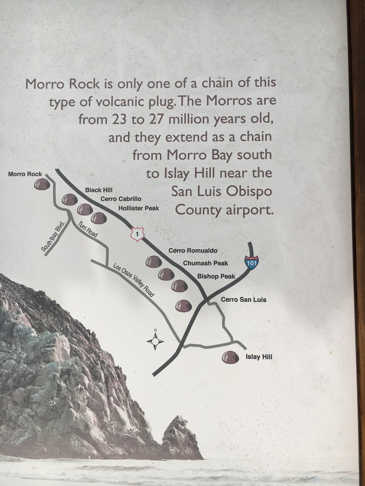
This whole area was geologically active due to plate tectonics. The Pacific Plate is subducting under the North American Plate along the west coast of California, resulting in faults. You have heard of the San Andreas Fault and its destructive power, but there are many other faults up and down the coast. Volcanoes form because of cracks in the earth’s surface, along fault lines. The Cascade Mountain range volcanoes are the result of faulting.

 This was the
season of Lent so we found a sweet little Lutheran Church in Morro Bay to
attend the Wednesday evening and Sunday morning services…Calary Evangelical
Lutheran Church. Founded in 1952 by the
Augustana Synod, this congregation worshipped about 35 people on Sunday. Like many other churches we have visited,
this church struggled with a diminishing membership and a decreasing budget. In spite of those problems, we found it to be
a warm and welcoming congregation.
This was the
season of Lent so we found a sweet little Lutheran Church in Morro Bay to
attend the Wednesday evening and Sunday morning services…Calary Evangelical
Lutheran Church. Founded in 1952 by the
Augustana Synod, this congregation worshipped about 35 people on Sunday. Like many other churches we have visited,
this church struggled with a diminishing membership and a decreasing budget. In spite of those problems, we found it to be
a warm and welcoming congregation.  Whoever planned the worship service did a great job of utilizing the
projection screen (you can see it rolled up at the right of the photo) to guide
the worship. We didn’t receive a
multi-page bulletin, rather followed the order of service as projected. It was very effective and well done!
Whoever planned the worship service did a great job of utilizing the
projection screen (you can see it rolled up at the right of the photo) to guide
the worship. We didn’t receive a
multi-page bulletin, rather followed the order of service as projected. It was very effective and well done! We got to
know Bruce and Bev Torg, members of Calvary, and went to dinner with them a few
times, as welll as attending the movie, “Martin Luther: An Idea That Changed the World”, sponsored by
Thrivent Financial. If you have a
chance, go see the movie go see it. We
were reminded of lots of 16th century history, as well as the story
of Martin Luther. What a character! The movie
was at a Regal Cinemas theater in Arroyo Grande, right across the highway from
A.J. Spurs! It was great excuse to have
dinner at this local landmark…yummy, too!
Great movie, great fellowship, and delightful new friends! Bruce was a
industrial pump specialist for most of his working life and travelled all over
the world. He had great stories,
including his humble beginnings in North Dakota.
Bev grew up on a dairy in Kerman, CA and had lots of milking cows twice a
day memories.
We got to
know Bruce and Bev Torg, members of Calvary, and went to dinner with them a few
times, as welll as attending the movie, “Martin Luther: An Idea That Changed the World”, sponsored by
Thrivent Financial. If you have a
chance, go see the movie go see it. We
were reminded of lots of 16th century history, as well as the story
of Martin Luther. What a character! The movie
was at a Regal Cinemas theater in Arroyo Grande, right across the highway from
A.J. Spurs! It was great excuse to have
dinner at this local landmark…yummy, too!
Great movie, great fellowship, and delightful new friends! Bruce was a
industrial pump specialist for most of his working life and travelled all over
the world. He had great stories,
including his humble beginnings in North Dakota.
Bev grew up on a dairy in Kerman, CA and had lots of milking cows twice a
day memories. 


Across from MerSea’s was a seafood market where we bought a yummy piece of swordfish for the grill. Grilling swordfish was new to us, so we asked the fisherman who waited on us how to cook it. It turned out so well I thought you might like to see his recipe:
Grilled Swordfish1 “ swordfish steaksSeasonings of choice. We used paprika, cayenne pepper, and Montreal steak seasoning
Melt butter in a cast iron skillet on the grill. Sprinkle seasonings on the melted butter. Cook the fish 7 minutes on each side with the skillet lid in place. I think this would work for any mild fish.


Fabulous!


Boater friends, Jim and Christie Caldwell from Ventura, drove up to visit us on Friday, April 7. We had done some buddy cruising with them when we had “Cosmo Place”. Their Nordic Tug, “Noeta”, was very similar to ours. We walked to the end of the pier in the rain to have lunch at MerSea…first time we had eaten there. Yummy crab sandwich!
Visalia friends Lynn and Maureen Heiges had a coastal home near Avila Beach, so we got to see them while we in the area. They showed us an amazing Mexican restaurant in San Luis Obispo. Some days it was all about the food!


We will be in Visalia for two weeks, visiting old friends. That will be a story for another day!